Rocklin Road Sierra College Corridor Multimodal Enhancements Virtual Community Meeting

Post

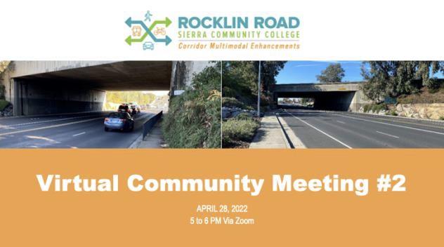
On Thursday, April 28th from 5:00 – 6:00 p.m., the City of Rocklin held its second Virtual Community Meeting for the Rocklin Road Sierra College Corridor Multimodal Enhancements. Below is a list of project team members that were in attendance:

City of Rocklin Jacobs AIM Consulting
Matt McClure Luke McNeel-Caird Gladys Cornell
Justin Nartker Michael Robinson Esme Santana

A total of 34 community members attended the Virtual Open House via Zoom.

The objective of the second virtual Community Meeting was to provide updates on the project, present five pedestrian and bicycle design options, answer any questions, and note any comments by the participants and have the participants rank in order of their preference the five pedestrian and bicycle design options.


About the Project

The City of Rocklin is making long-term operational and circulation improvements within the area of the Rocklin Road/Interstate 80 Interchange. The improvements will address existing traffic congestion and improve walking and biking connections between downtown Rocklin and Sierra College.


Meeting Format, Objectives and Purpose

The meeting was held online through Zoom. In addition to presentations, informational videos and two Question and Answers sessions, the meeting included online polling.

The Community Meeting started with the facilitator Gladys Cornell, AIM Consulting welcoming attendees, providing a brief meeting orientation and introduced the project team and agenda. She then discussed the previous public outreach which included the first Virtual Community Meeting, two Stakeholder Meetings and site visits with four property owners. In addition, the collaborative video, Weekend Get Away in Placer County, that was made by Capitol Corridor Joint Power Authority (CCJPA) in partnership with Placer County Transportation Planning Agency (PCTPA), was shown to participants.

Matt McClure, Public Services Manager and Project Manager with the City of Rocklin provided welcoming remarks and a background of the project. He explained the current configuration requires those walking or riding bicycles must ride and walk very closely alongside motorists which is a safety concern for many of the traveling public. The intent of this project is to improve the traveling experience for all pedestrians and cyclists of all ages and abilities.

McClure also cited a 2017 survey conducted by Placer County Transportation Planning Agency, indicated that people wanted better access to Sierra College and downtown Rocklin in addition to overall better alternatives to crossing I-80, safely.

Luke McNeel-Caird, Senior Project Manager with Jacobs, presented an overview of the Rocklin Road traffic circulation. He presented data from 2017 showing that the total number of cars that travel on Rocklin Road are 22,790 and is predicted to grow during the next six years.

McNeel-Caird walked attendees through a real-time traffic modeling video illustrating the data and the current traffic conditions within the area. McNeel-Caird also provided participants with a video illustrating how the proposed Diverging Diamond Interchange (DDI) works, along with the proposed bicycle and pedestrian improvements. He highlighted that the DDI will remain the same for all the design concepts but that the alternatives have different approaches for improving the bicycle and pedestrian experience.

McNeel-Caird presented five pedestrian and bicycle options at this meeting. Since the last community meeting, the project team narrowed down the design concepts to Alternative 1 and Alternative 2. Alternative 1 offers 3 options and Alternative 2 has two options for pedestrian and bicycle travel along Rocklin Road. The project team then paused to answer any clarifying questions related to the options. Once the questions were answered, the project team reviewed the evaluation criteria for the five options. The criteria included topics such as total cost, construction schedule, project approval and public acceptance.

After the criteria was presented, participants were offered an online poll to rank their preference for each of the design options.


Design Concepts Discussion

The presentation began with an overview of the five different bicycle and pedestrian option proposals.

The five options are displayed below.


Alternative 1: Option A


Alternative 1: Option B


Alternative 1: Option C


Alternative 2: Option A


Alternative 2: Option B


Polling

To get an understanding of the public’s acceptance of these options, a preference poll was conducted during the presentation. Attendees were given instructions on how to access the poll and had the opportunity to rank the options from 1 to 5, with 1 being their preferred option and 5 being their least favorite option.

The survey was taken by 19 people and the results are shown below. The highest rank for Alterative 1 is Option A and the highest rank for Alternative 2 is Option A.


Questions & Answers Sessions

Two Q&A sessions were provided to participants to allow for community members to understand the project need and design options prior to their opportunity to provide their preference. The second Q&A session allowed participants to ask any additional questions about the project and provide any final comments for the project team to consider as they move through the project development process.

Cornell, who was monitoring the chat box, presented community member’s questions. Below are the questions with a general summary.


First Q&A Session

Q: “Are there any negative impacts to the business in the area? Are any of the businesses going to be removed?”
A: Right now, there are five businesses that are potentially impacted by this project. We have met with all of them to discuss the project. The ARCO and 76 gas stations are special cases. At the Arco, we met them on-site and we may need to reconfigure their driveways. At 76 gas station, the gas pumps are on the side of the Rocklin Road may need to be relocated. We will continue working with these business owners as we refine the design. Starbucks, Rocklin Road Dry Cleaners, Stop & Go Liquor, and KFC are not being impacted. The Arby’s will have a sliver of right of way but the drive thru will be maintained. The vacant property in the northeast quadrant of the interchange will also have a sliver of right of way and existing unpaved driveway will need to be reconstructed.

Q: “Are staircases in all of the options?”
A: There are stairs only in options A, B, and C for Alternative 1. Alternative 2 does not need staircases.

Q: “Has a bus lane been considered?”
A: There are two transit stops just East of Rocklin Road Interchange, near Sierra College, both Eastbound and Westbound on Rocklin Road. Along Rocklin Road, there is so much traffic in the morning and evening, and with the DDI, not only will it improve traffic, but it will also help the several transit lines that travel through.

Q: “Does the project team have data on the number of vehicles entering the freeway that yield to pedestrians? It’s pretty rare to see in my experience.”
A: We know that motorists do not yield to pedestrians and right now our goal is to separate the motorists, the bicyclists, and the pedestrians. Our main concern is with the Eastbound on-ramp. With the Eastbound on-ramp, it’s an uncontrolled movement and we are looking into that. We’re looking into angles to see how drivers coming into that area can look for pedestrians and bicyclist. The Westbound off ramp will be less of a concern due to it being signalized.

Q: “So looking at the plans, it looks like 2 open driveways for us [ARCO Gas Station], correct?”
A: We are still working through the design and waiting to hear back from the City of Rocklin and Caltrans. Our goal will be to try to find a way to provide you with 2 access points.

Q: “Does option 2B have lights and security cameras?”
A: It will have lights, and we will have to evaluate the installation of security cameras. If there is significant community support, then we would have to take that into consideration.

Q: “Option 2A and 2B sound better for pedestrians and bicyclists. Option 2B being closed off sounds more dangerous for children. Can you explain more ‘closed -off’?”
A: Since Option B is offset that means that you won’t be able to see in the undercrossing, but provisions will be considered for ventilation and safety.

Q: “Any data on the safety of diverging diamond interchanges versus more traditional interstate designs for cyclists that ride in the same lanes as motorists?”
A: The diverging diamond interchanges are designed to slow down the general traffic to 15-20 mph. Bicyclists will use the separate trail that will be design to allow pedestrians and bicyclists to travel in both directions. However, since Rocklin Road will be designed for a much slower speed, cyclists that decide to stay in the lanes instead of going with the multi-use path, will be dealing with a much slower speed of traffic.


Second Q&A Session:

Q: “The decision matrix does not seem to account for long term viability. Car traffic is bound to get worse and making a bike path that people actually use will be the correct way to keep the traffic at bay. If you select the more direct bicycle and pedestrian design, will this really encourage more people to walk and bike and ultimately, reduce the number of cars long term?”
A: We understand the more direct path for bicycles and pedestrians is desired and that some people will not want to walk up and down the staircases and down the long path to get to their destinations. It’s not time efficient for those that are in a rush to get to school, work, or other places. However, the more direct path has a higher cost and does not have the opportunity for a City gateway, which should be taken into consideration. Alternative 1 paths would include trees for shade for those that are using the travel as recreation.

Q: “Why is undercrossing more expensive than Alternative 1?”
A: That has to do with either extending or constructing a seperate I-80 bridge structure.

Q: “I know you mentioned that these changes are aiming to lean towards being more recreational, but I thought that this project was based on the [Sierra] college and to reduce traffic during school hours. So, if we’re catering to be more recreational rather than to the Sierra Community College students, that’s a concern for me.”
A:
I want to clarify the options are for everybody, Alternative 1 provides for recreational opportunities, but it does include a staircase for the person that needs to get to their destinations more quickly.


Draft Comparison Table and Schedule

After the discussion of the options and general comments, the project team presented a table with a comparison of all five options and the projected project schedule.


Next Steps

The meeting came to conclusion with the project team encouraging the public to reach out to them with any questions or concerns, and highlighting the next steps as follows:

  • Approval of Engineering and Environmental Technical Studies – In progress
  • Public Input Survey – April to May 2022
  • Stakeholder Meeting #3 – Summer 2022
  • Community Meeting #3 – Fall 2022
  • Draft environmental document – Fall 2022

Download the Meeting Summary:
Rocklin Road/Sierra College Corridor Multimodal Enhancements Virtual Community Meeting Summary